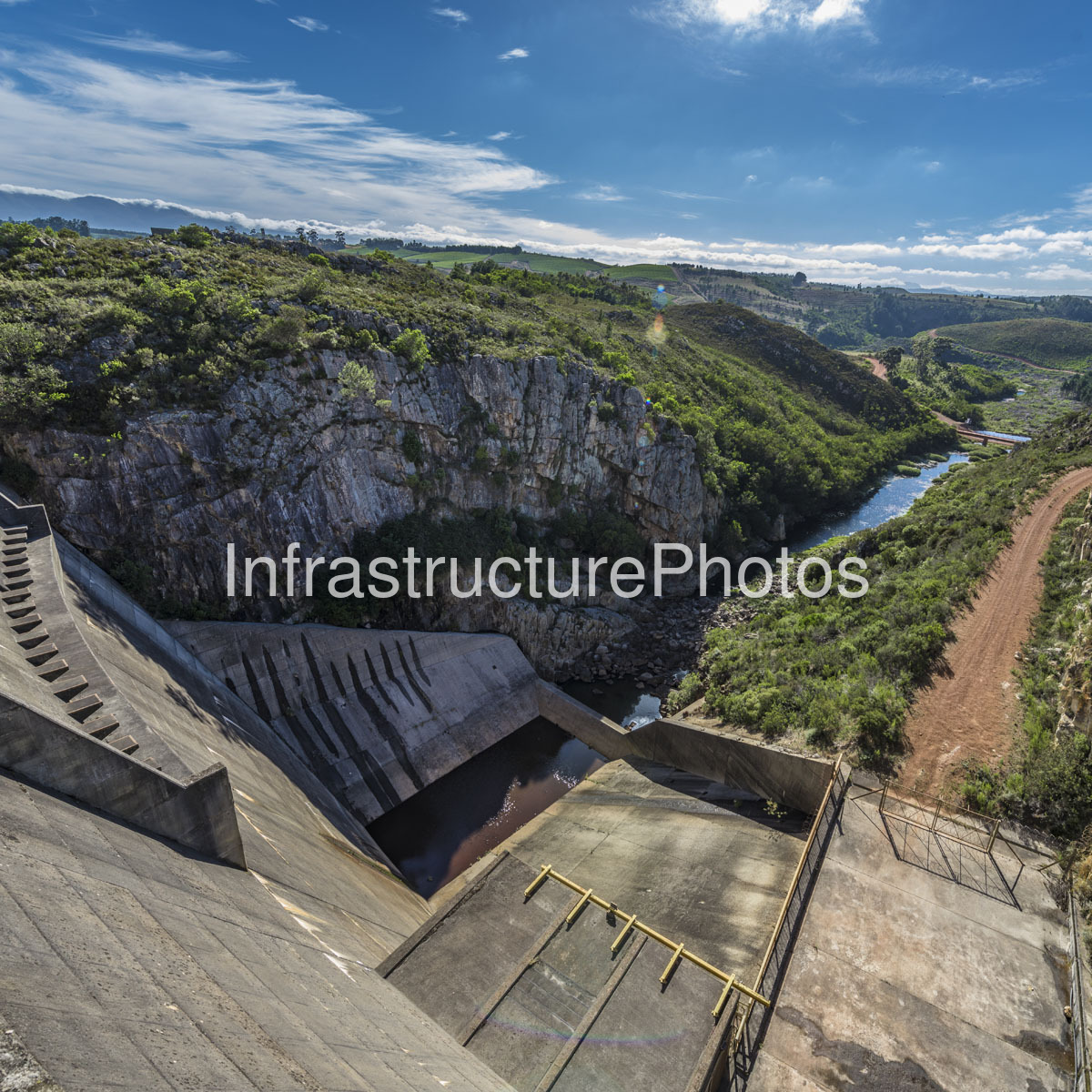
This photograph provides a dramatic elevated view across the downstream side of Kogelberg Dam, showing the concrete spillway and hydraulic works descending into the rugged Palmiet River gorge. The image captures the meeting point between major water infrastructure and the mountainous fynbos landscape of the Western Cape, with the engineered concrete structures occupying the foreground and the Palmiet River continuing through a narrow, heavily vegetated valley beyond.
Kogelberg Dam forms the lower reservoir of the 400 MW Palmiet Pumped Storage Scheme, operated by Eskom. The dam is located on the Palmiet River south of Grabouw, within the mountainous landscape associated with the Kogelberg region. The upper reservoir of the scheme is Rockview Dam, located on the watershed between the Palmiet and Steenbras river systems. Together, the two reservoirs form an integrated pumped-storage and water-transfer system.
The principal structure visible in the foreground is the dam’s large concrete spillway, which is designed to safely convey excess water from the reservoir into the Palmiet River downstream. Eskom’s technical specifications identify the Kogelberg Dam spillway as an ogee-type spillway with a capacity of approximately 1,060 m³/s. The dam has a maximum height of approximately 57 metres above the riverbed, while the concrete wall has a crest length of approximately 186 metres.
The stepped and sloping concrete surfaces visible in the photograph form part of the spillway and energy-dissipation system. These structures control the movement of water as it descends from the reservoir and help manage the considerable hydraulic forces generated during high-flow conditions. At the bottom of the spillway, water is directed back towards the natural Palmiet River channel, which can be seen continuing through the rocky gorge.
The scale of the hydraulic engineering is particularly evident from this viewpoint. Massive reinforced-concrete surfaces extend across the foreground, while the river below appears comparatively small. The contrast demonstrates how the dam infrastructure has been engineered to control a watercourse that otherwise passes through a steep and rugged natural valley.
Kogelberg Dam is a mass concrete gravity arch wall with a separate earth saddle embankment. Eskom records approximately 70,000 m³ of concrete in the dam wall and approximately 220,000 m³ of earth embankment material. The reservoir has a full supply level of approximately 246 metres above sea level, a gross storage capacity of approximately 19.3 million m³ and an active storage capacity of approximately 15 million m³. At full supply level, the reservoir covers approximately 155.4 hectares.
Beyond its conventional role as a dam, Kogelberg is an important component of South Africa’s pumped-storage electricity infrastructure. During periods of low electricity demand, water can be pumped from Kogelberg Dam uphill to Rockview Dam. When additional electricity-generation capacity is required, the stored water is released from Rockview through the underground waterways towards the Palmiet power station. The potential energy created by the elevation difference is converted into electricity by two reversible pump-turbine units, each rated at approximately 200 MW.
One of the defining characteristics of the Palmiet scheme is that much of its major infrastructure is underground. The power station is located approximately two kilometres upstream of the Kogelberg Dam wall, while the two pump-turbine units are installed underground at the base of deep vertical machine shafts. The underground arrangement helped reduce the visual impact of the project within the sensitive mountain environment.
The photograph also provides a useful view of the tailworks and downstream hydraulic environment. Eskom’s engineering documentation describes twin tailrace shafts connecting the underground generating units to the lower Kogelberg reservoir, together with control and access towers and reinforced concrete works in the lower reservoir area. The downstream waterway visible in this image therefore forms part of a much larger hydraulic system extending underground beneath the surrounding landscape.
The Palmiet scheme can operate in both generation and pumping modes. In generating mode, water from Rockview travels through a surface headrace tunnel and a series of underground waterways before reaching the pump-turbines. Eskom’s technical documentation records a main waterway approximately 6.2 metres in diameter, with flows of up to approximately 185 m³/s during generation. After passing through the turbines, water is discharged towards the lower Kogelberg reservoir.
The surrounding landscape is equally significant. The steep rock faces visible on either side of the Palmiet River are covered by dense indigenous vegetation characteristic of the Cape Floristic Region. The Kogelberg area is particularly important for fynbos biodiversity and forms part of the Kogelberg Biosphere Reserve. The reserve was designated by UNESCO in 1998 and represents one of the world’s important centres of plant diversity.
The photograph demonstrates the unusual relationship between the infrastructure and its environment. The dam’s concrete surfaces are stark, geometric and highly engineered, while immediately beyond them the landscape returns to rugged rock, indigenous vegetation and the natural river corridor. The transition is especially striking along the right side of the image, where an unpaved access track follows the edge of the gorge.
The Palmiet project was developed with considerable emphasis on environmental integration. Eskom describes it as a forerunner in environmental engineering, and the project received several awards recognising its engineering and environmental achievements. These included recognition by the South African Institution of Civil Engineering and, in 2003, the International Hydropower Association’s Blue Planet Prize for its technical, economic and environmental performance.
The wider water-management role of the scheme is also important. Kogelberg forms part of the Palmiet River water system and is linked to water-transfer infrastructure associated with the Steenbras system. Water-resource records maintained by the Department of Water and Sanitation identify Kogelberg Dam as a major reservoir on the Palmiet River, with the official hydrological monitoring station designated G4R006.
The downstream Palmiet River is particularly visible in this photograph, where the narrow channel winds between exposed rock and dense vegetation. The river’s relatively modest appearance contrasts with the enormous concrete hydraulic structures in the foreground, illustrating how infrastructure has been superimposed onto an existing natural valley without completely overwhelming its character.
The image is therefore more than a conventional dam photograph. It documents an important piece of South African infrastructure where hydropower, pumped energy storage, water management, civil engineering and environmental conservation intersect. The spillway provides the most obvious evidence of the dam itself, while the river gorge and surrounding mountains reveal the demanding natural environment in which the project was constructed.
The combination of hard concrete geometry, exposed geological formations, indigenous vegetation and clear Western Cape skies gives the photograph a strong sense of scale. The viewpoint also illustrates how the Palmiet scheme was deliberately integrated into the terrain: much of the most substantial electrical and hydraulic infrastructure remains concealed underground, leaving the dam and its spillway as the principal visible elements.
Kogelberg Dam remains an important example of multi-purpose infrastructure in a sensitive natural landscape. Its reservoir provides the lower storage component of the Palmiet pumped-storage system, its hydraulic works support rapid electricity generation and pumping operations, and its connection to the Palmiet River contributes to wider regional water management. The photograph captures the downstream face of that system at the precise point where engineered water control returns to the natural river environment.
20 MB
Reviews
There are no reviews yet.