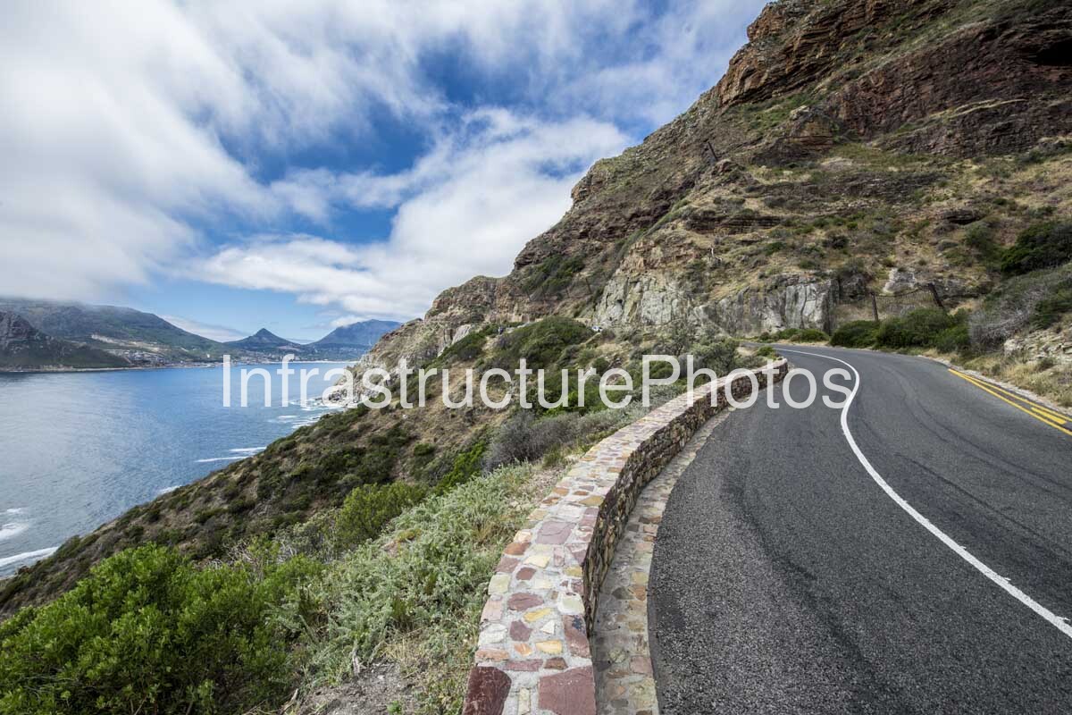
This photograph captures one of the most spectacular sections of Chapman’s Peak Drive, with the historic coastal road carved directly into the steep western slopes of Chapman’s Peak above the Atlantic Ocean. The image looks along the sweeping roadway as it curves around the mountain, with a substantial stone-faced retaining wall protecting the seaward edge. Across the water, the mountains surrounding Hout Bay form a dramatic backdrop, while the exposed rock strata and indigenous vegetation emphasise the rugged character of the Cape Peninsula.
Known locally as “Chappies,” Chapman’s Peak Drive forms part of the M6 and connects Hout Bay with Noordhoek along approximately 9 km of spectacular coastline. The road contains 114 curves and follows the steep western flank of Chapman’s Peak, a 593-metre-high southern extension of Constantiaberg. The route provides an important transport connection between Cape Town and the South Peninsula while also functioning as one of the city’s most famous scenic attractions.
The road was constructed between 1915 and 1922 under the direction of the Cape Provincial Administration. Construction began from the Hout Bay side in 1915, with work commencing from Noordhoek the following year. The completed Hout Bay–Noordhoek road was officially opened on 6 May 1922 by Prince Arthur of Connaught, Governor-General of the Union of South Africa. At the time, cutting a road into the steep and unstable mountainside was regarded as a remarkable engineering achievement.
The engineering of the original route remains one of its most impressive characteristics. Rather than crossing over the mountain, the road was constructed along the contact between different geological formations, allowing engineers to create a relatively continuous ledge across the otherwise precipitous slope. SANParks describes Chapman’s Peak as being primarily characterised by hard, quartzitic Table Mountain Sandstone resting above Cape Granite, while historical accounts note how the roadway was engineered through this geological transition.
The exposed mountainside dominates the right-hand side of the photograph. Clearly visible layers of sedimentary rock run horizontally and diagonally through the cliff, revealing the geological history of the Cape Peninsula. The weathered strata have been shaped by millions of years of erosion, producing the rugged cliffs, shelves and steep ravines that made construction of the road so challenging. Vegetation has established itself wherever sufficient soil and moisture have accumulated, softening parts of the otherwise harsh rock face.
The road itself demonstrates how closely the infrastructure follows the natural contours of the mountain. Rather than imposing a straight alignment on the landscape, the carriageway sweeps around the contours, producing a sequence of curves that are characteristic of Chapman’s Peak Drive. The smooth asphalt contrasts strongly with the rough geological surfaces immediately above and below it.
The stone-faced retaining wall visible along the left side of the roadway is an important part of the infrastructure. Constructed from locally appropriate stone, the wall provides a physical barrier between vehicles and the steep drop towards the ocean while helping retain the road formation. Its masonry construction also integrates remarkably well with the surrounding geology, making the engineering intervention appear almost like a continuation of the natural mountainside.
The view towards Hout Bay is particularly significant. Across the Atlantic inlet, the mountains form a distinctive sequence of peaks and ridges surrounding the bay. The sheltered waters of Hout Bay appear calmer than the open Atlantic visible further along the coastline, while the settlement is tucked between the surrounding mountains. From Chapman’s Peak Drive, this relationship between mountain, settlement and ocean creates one of the defining vistas of the Cape Peninsula.
Chapman’s Peak itself takes its name from John Chapman, the pilot and captain’s mate of the English ship Consent. In 1607, after the vessel became becalmed near what is now Hout Bay, Chapman was sent ashore to search for provisions. The name associated with him subsequently appeared on East India charts and eventually became attached to both the mountain and the famous road.
The road’s history has also been closely connected with the considerable geological risks of the mountainside. Rockfalls and landslides have periodically affected Chapman’s Peak Drive. A major rockfall and subsequent safety concerns eventually resulted in the road being closed indefinitely in 2000. The subsequent rehabilitation programme incorporated extensive rockfall protection, improved safety measures and structural interventions before the road reopened as a toll road in 2003.
The modern road therefore represents a combination of historic alignment and contemporary engineering. The basic route remains the one created in the early twentieth century, but modern protection measures have been introduced to address the geological hazards inherent in constructing a road beneath steep cliffs. The rehabilitation included rockfall canopies, protective structures, reinforced sections and improved road infrastructure.
The photograph captures this relationship particularly well. The road appears almost suspended above the Atlantic, with the retaining wall defining the boundary between the engineered surface and the steep natural slope. The narrow coastal strip below illustrates the limited amount of developable land available between the mountain and the ocean.
Chapman’s Peak Drive is also an important part of Cape Town’s sporting landscape. The road forms part of the route of the Cape Town Cycle Tour and the Two Oceans Marathon, making it familiar to thousands of cyclists and runners. Its combination of steep gradients, sweeping curves and spectacular ocean views has made it one of the most memorable sections of these major events.
For cyclists in particular, Chapman’s Peak has become an iconic feature of the Cape Town Cycle Tour. The climb and descent provide both a physical challenge and some of the most spectacular scenery on the route. The road’s relatively narrow carriageway and numerous curves also demonstrate why careful traffic management and modern safety measures remain important.
The image was photographed in January 2018, during the Cape Peninsula’s summer season. The combination of blue sky, scattered cloud, clear ocean water and green coastal vegetation creates a strong contrast with the dark grey asphalt and weathered brown and grey rock. The lighting reveals the texture of both the geological strata and the stone retaining wall, giving the photograph considerable depth.
This is ultimately a photograph about infrastructure integrated into landscape. Chapman’s Peak Drive does not simply pass through the mountains; it has been carefully fitted into them. The roadway, retaining wall and protective infrastructure occupy a narrow strip between the mountain and the sea, demonstrating the ingenuity required to create a reliable transport route through one of Cape Town’s most challenging natural environments.
28.41 MB
Reviews
There are no reviews yet.