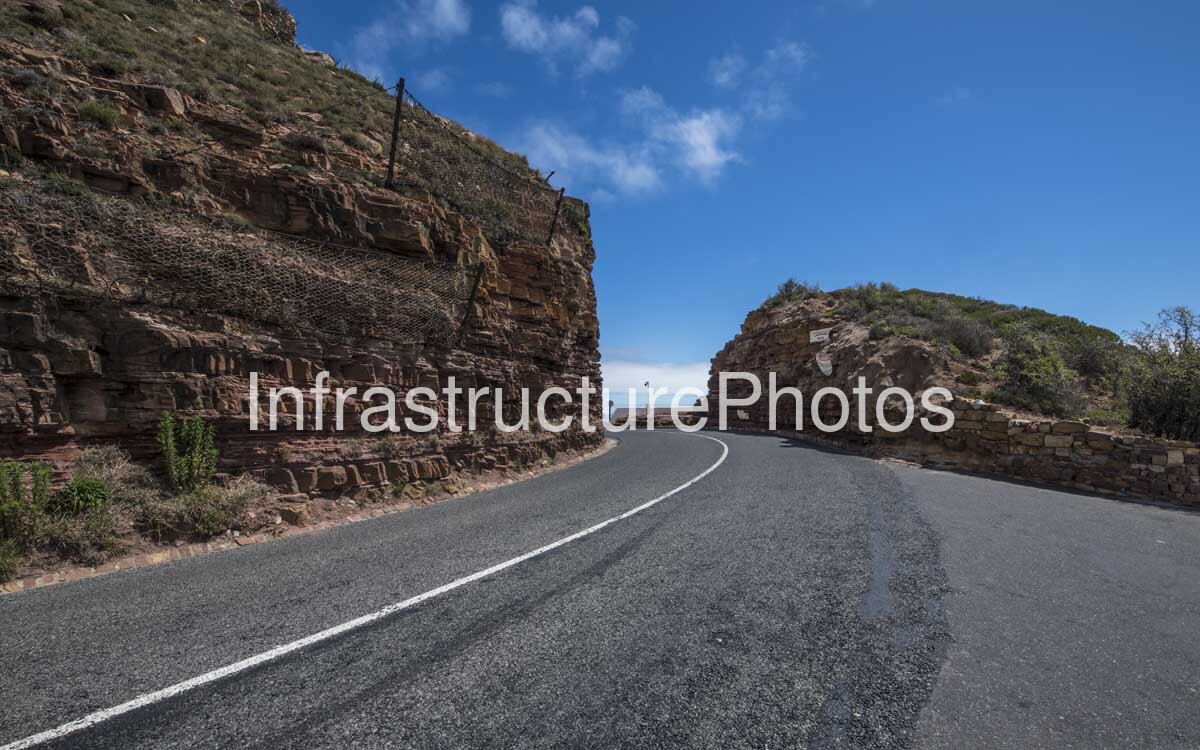
This photograph captures a dramatic rock-cut section of Chapman’s Peak Drive on the Cape Peninsula, showing how the historic coastal road has been carved directly through the steep sandstone and granite mountainside. The image places the road at the centre of the composition, with massive exposed rock cuttings on both sides and a glimpse of the Atlantic Ocean visible through the opening ahead. The combination of the engineered roadway, stone retaining walls, rockfall protection and naturally stratified mountainside provides a powerful illustration of the engineering challenges involved in creating and maintaining one of South Africa’s most famous coastal roads.
Known locally as “Chappies,” Chapman’s Peak Drive forms part of the M6 and connects Hout Bay with Noordhoek. The approximately 9-kilometre route contains 114 curves and follows the steep western slopes of Chapman’s Peak above the Atlantic Ocean. It is simultaneously an important transport connection, a major tourism attraction and an internationally recognised example of scenic road engineering. SANParks describes the route as a vital transport link and a world-renowned scenic experience within the Table Mountain National Park.
The road was constructed between 1915 and 1922 under the Cape Provincial Administration. Preliminary surveys began in 1914, when engineers faced an exceptionally difficult landscape of steep cliffs, ravines and unstable rock. Construction began from the Hout Bay side in 1915, followed by work from Noordhoek in 1916. The completed Hout Bay–Noordhoek road was officially opened on 6 May 1922 by Prince Arthur of Connaught, Governor-General of the Union of South Africa.
The engineering concept behind Chapman’s Peak Drive was particularly ingenious. Historical records describe how the road alignment was planned around the underlying geological formations, with the road surface taking advantage of the solid Cape Granite while roadside cuttings were made through the more workable Malmesbury sediments. This allowed engineers to establish a relatively continuous route along an otherwise extremely steep coastal mountainside.
The photograph provides an excellent close-up view of the consequences of this approach. The road passes through a substantial cutting where the mountain has effectively been sliced open to create sufficient width for two-way traffic. The exposed rock walls reveal clearly defined horizontal and near-horizontal layers, with individual beds fractured and weathered over geological time. The reddish-brown and ochre tones of the rock contrast strongly with the dark asphalt and bright blue sky.
The rock face on the left is particularly significant from an engineering perspective. A substantial area of rockfall meshhas been installed across the upper and middle portions of the cutting. The mesh is anchored to the mountainside and is designed to restrain loose and potentially unstable rock fragments, helping to prevent material from reaching the carriageway. This type of slope stabilisation is an important component of the modern safety infrastructure along Chapman’s Peak Drive.
The wire mesh visible in this photograph is part of the broader evolution of the road from a pioneering early twentieth-century engineering project into a modern, actively managed mountain highway. Natural weathering, heavy rainfall and the steep geological structure of the mountains create continuing risks of rockfall and slope instability. SANParks notes that the area has required ongoing engineering interventions, including rock nets, tunnels and reinforced barriers, to maintain road safety while preserving the character of the historic route.
The stone-faced wall on the right side of the road is another important infrastructure element. Built from locally appropriate stone, it provides a strong physical edge to the carriageway and helps retain the road formation where the terrain falls away. Its construction also demonstrates an important characteristic of Chapman’s Peak Drive: infrastructure has frequently been designed to visually complement the surrounding geology rather than appearing as a completely separate modern intervention.
The roadway itself is relatively simple in appearance, consisting of a two-lane asphalt carriageway with a clearly defined central white line and yellow edge markings. Yet the simplicity of the finished road conceals the complexity of its construction. Every section of pavement visible in the photograph represents an engineered platform established within extremely steep terrain.
At the centre of the image, the road curves gently towards an opening in the rock. Beyond the cutting, a narrow glimpse of the Atlantic Ocean provides an immediate reminder of the route’s extraordinary location. The road effectively forms a passage through the mountain, with the opening ahead revealing the coastal landscape beyond.
Chapman’s Peak Drive has had a long history of dealing with geological instability. In 1994, a landslide resulted in a motorist being seriously injured, and subsequent legal proceedings highlighted concerns about the management and safety of the route. Following further investigations and extensive rock-barring and safety assessments, the road was eventually closed in 2000.
The subsequent rehabilitation programme fundamentally changed the way the road’s geological risks were managed. Rather than simply removing every potentially loose rock from the mountain, engineers adopted an integrated approach involving selective rock-barring together with engineered rockfall protection. Proposed and implemented measures included catch fences, rockfall galleries, concrete protection structures, repairs to existing structures, road-surface rehabilitation and slope stabilisation.
26 MB
Reviews
There are no reviews yet.