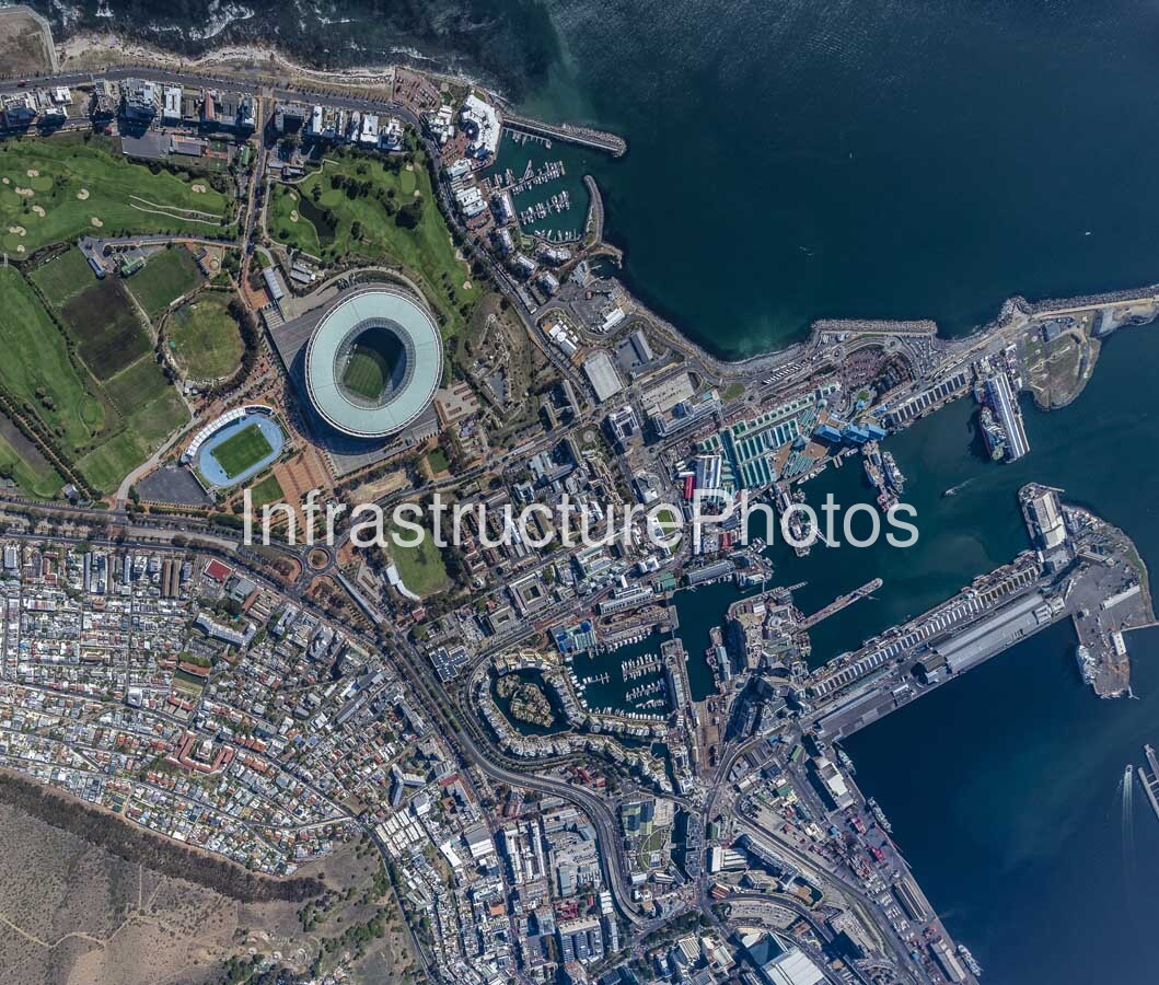
This spectacular aerial photograph captures the heart of Cape Town’s Green Point and V&A Waterfront precinct from directly above, with DHL Stadium forming the dominant landmark on the western side of the image. The photograph brings together major sporting infrastructure, Green Point’s extensive open spaces, the V&A Waterfront, marinas, working harbour facilities, transport infrastructure and the Atlantic coastline in a single highly detailed composition. It provides an exceptional record of the relationship between Cape Town’s urban development and its historic maritime environment.
The most prominent structure is DHL Stadium, formerly Cape Town Stadium, positioned within the Green Point precinct. Designed for the 2010 FIFA World Cup, the stadium was constructed between 2007 and 2009. The architectural design was led by Volkwin Marg and Hubert Nienhoff with Robert Hormes of gmp Architekten, in association with Louis Karol Architects and Point Architects in Cape Town. The stadium has a capacity of approximately 68,000 spectators and is characterised by its circular geometry, sweeping translucent roof and lightweight structural expression. Its 36,000-square-metre roof incorporates a cable-supported trussed structure and translucent glazing designed to respond to Cape Town’s strong sunlight and weather conditions.
The stadium sits within a substantial landscape of sports fields, pedestrian areas and public open space. The aerial view clearly shows the relationship between the stadium and the adjacent athletics facilities, playing fields and landscaped areas. The surrounding road network provides important connections between Green Point, the V&A Waterfront and Cape Town’s central city, while the stadium’s carefully positioned footprint creates a strong geometric landmark within the broader urban landscape.
Immediately east of the stadium is the V&A Waterfront, one of Cape Town’s most significant mixed-use urban precincts. The Waterfront incorporates commercial buildings, hotels, residential development, retail, entertainment, cultural attractions, marinas and an active working harbour. The wider precinct includes the Victoria Basin, Alfred Basin, Duncan Dock, Silo precinct and other harbour areas, creating an unusually diverse combination of contemporary urban development and maritime infrastructure.
The harbour occupies much of the right-hand side of the photograph, revealing an intricate network of quays, breakwaters, berths, docks and marine facilities. The scale of this infrastructure becomes particularly apparent from the aerial perspective. Large vessels can be seen within the harbour, while smaller marina facilities occupy the sheltered waters closer to the Waterfront. The area remains an operational maritime environment, connecting commercial and recreational activity with Cape Town’s historic port functions.
DHL Stadium, Cape Town Stadium, Green Point, Green Point Urban Park, Green Point sports facilities, V&A Waterfront, Victoria Basin, Alfred Basin, Duncan Dock, Port of Cape Town, Cape Town harbour, harbour breakwaters, marinas, quays, commercial development, residential neighbourhoods, road infrastructure, Atlantic Ocean, coastal infrastructure, aerial cityscape.
35 MB
Reviews
There are no reviews yet.