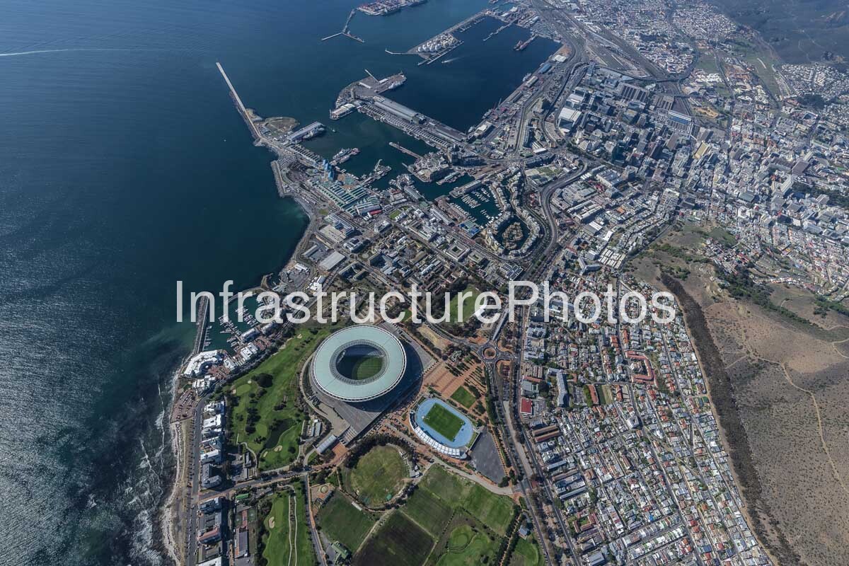
This expansive aerial photograph captures a remarkable cross-section of Cape Town’s western city centre, revealing DHL Stadium, Green Point’s sporting and recreational precinct, the V&A Waterfront, the Port of Cape Town and the Atlantic coastline in a single frame. The elevated perspective provides an exceptional understanding of how major sporting infrastructure, public open space, residential neighbourhoods, commercial development, transport networks and a working harbour have been integrated into one of South Africa’s most important urban environments.
The dominant landmark is DHL Stadium, formerly Cape Town Stadium, clearly visible near the centre of the photograph. Built for the 2010 FIFA World Cup, the stadium was constructed between 2007 and 2009. Its architectural design was led by gmp Architekten, with Volkwin Marg and Hubert Nienhoff working with Robert Hormes, in a joint venture with Louis Karol and Point Architects of Cape Town. The stadium accommodates approximately 68,000 spectators and is distinguished by its elliptical bowl, sweeping roof and lightweight structural design. From the air, the building’s circular geometry and pale roof create a powerful focal point against the surrounding green landscape.
The stadium forms part of the wider Green Point precinct, which includes extensive landscaped areas, sporting fields, an athletics track and public recreational space. The relationship between the stadium and these surrounding facilities is particularly clear from this altitude. Rather than appearing as an isolated structure, DHL Stadium is embedded within a substantial urban park and sporting landscape that connects the Green Point neighbourhood with the V&A Waterfront and the Atlantic coastline.
Immediately beyond the stadium lies the V&A Waterfront, one of Cape Town’s most significant examples of waterfront regeneration. The precinct covers approximately 123 hectares and has evolved from a historic harbour environment into a mixed-use neighbourhood incorporating offices, residential buildings, hotels, retail, entertainment, cultural attractions, marinas and public spaces. Importantly, the Waterfront continues to operate alongside an active working harbour rather than replacing its maritime function.
The harbour infrastructure occupies a substantial portion of the upper and right-hand areas of the photograph. Long breakwaters, quays, docks, berths and marine facilities create a complex network extending into Table Bay. The V&A Waterfront includes approximately 3.5 kilometres of quay walls and jetties in regular use, while fishing vessels, yachts, commercial vessels, cruise ships and other maritime operations remain an important part of the working waterfront.
The image also captures the distinctive layout of the Waterfront’s marinas and basins. The sheltered waters contrast with the open Atlantic Ocean along the western edge of the photograph, while the curved shoreline and harbour walls demonstrate how engineering has shaped the interface between Cape Town and the sea.
South and east of the stadium, dense residential and commercial development spreads towards Cape Town’s central business district. Major roads curve around the stadium and Waterfront, connecting the precinct to the wider metropolitan transport network. The aerial perspective makes the contrast between the ordered geometry of the harbour, the circular form of DHL Stadium, the landscaped public spaces and the dense urban street pattern particularly striking.
33 MB
Reviews
There are no reviews yet.