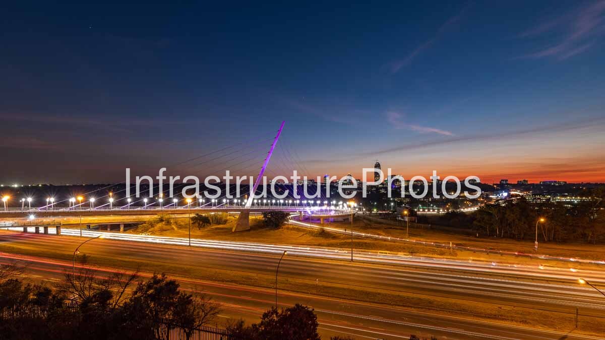
This photograph captures the Grayston Pedestrian and Cycle Bridge at dusk, with the Sandton skyline forming a dramatic backdrop beyond the M1 motorway. The illuminated bridge, flowing traffic and fading sunset combine to create a striking image of Johannesburg’s urban infrastructure and one of South Africa’s most recognisable business districts.
The Grayston Pedestrian and Cycle Bridge forms part of the pedestrian and cycling connection between Sandton and Alexandra, crossing the M1 motorway at Grayston Drive. Its distinctive cable-stayed design is immediately recognisable from the single inclined pylon and radiating suspension cables. The structure provides a dedicated route for pedestrians and cyclists across a major transport corridor while also creating a significant architectural landmark within the Johannesburg landscape.
At dusk, the bridge becomes particularly prominent. Its lighting traces the length of the structure and highlights the individual cables extending from the angled pylon. The illuminated lines create a strong visual contrast against the darkening sky and surrounding landscape. The bridge’s diagonal pylon also provides a powerful compositional element, directing the eye upwards and towards the Sandton skyline.
The M1 motorway dominates the foreground of the photograph. This major north-south arterial route carries substantial volumes of traffic through Johannesburg and connects important commercial and residential areas of the metropolitan region. The long-exposure technique transforms the moving vehicles into continuous ribbons of white and red light, illustrating the constant movement along the highway.
The combination of bridge and motorway demonstrates two very different forms of urban mobility. The M1 is designed primarily for high-volume vehicular movement, while the Grayston bridge provides a dedicated crossing for pedestrians and cyclists. Together, they demonstrate the increasingly diverse infrastructure required to connect communities and support movement through a major metropolitan area.
Beyond the bridge, the Sandton skyline rises above the surrounding landscape. The cluster of high-rise buildings is particularly striking against the orange band of sunset. Sandton has developed into one of Johannesburg’s principal commercial centres, with a concentration of corporate offices, hotels, residential towers, retail facilities and major transport infrastructure.
The skyline visible in this image demonstrates the contrast between Sandton’s high-density commercial core and the lower-rise urban landscape surrounding it. Tall buildings form a concentrated cluster towards the horizon, while lower buildings, roads, vegetation and open areas occupy the foreground and middle distance.
The photograph was taken during the short period between sunset and nightfall, when artificial lighting begins to dominate the scene while sufficient natural light remains to reveal the surrounding landscape. The sky progresses from deep blue overhead to orange and gold along the horizon, creating a strong gradient behind the buildings.
The lighting also reveals the extensive infrastructure surrounding the M1. Streetlights illuminate the road network, while buildings and other urban facilities begin to glow as daylight disappears. These individual points of light collectively demonstrate the scale and activity of the metropolitan environment.
The Grayston bridge was completed as part of the Great Walk project, an initiative aimed at improving pedestrian and cycling connections between Alexandra and Sandton. The project was designed to provide safer movement across the M1 and strengthen connections between communities and the employment opportunities, services and transport facilities located around Sandton.
The bridge’s engineering and architectural design give it an unusually strong visual identity. The inclined pylon creates a dramatic vertical and diagonal form, while the numerous cables produce a fan-like pattern across the sky. At night, the lighting emphasises this geometry and transforms the bridge into a highly visible landmark.
The surrounding highway infrastructure provides a useful contrast to the bridge’s elegant form. Multiple lanes, ramps, lighting columns and traffic movements create a complex horizontal network beneath the cable-stayed structure. From this elevated viewpoint, the different layers of infrastructure can be seen operating together.
The image also records the relationship between Johannesburg’s natural and built environments. Areas of vegetation and open land remain visible around the transport infrastructure, while the dense Sandton skyline forms a concentrated urban centre in the distance. This combination is characteristic of Johannesburg’s metropolitan landscape, where extensive green spaces and low-density development coexist with increasingly dense commercial nodes.
From an architectural and infrastructure photography perspective, the image is particularly effective because it captures the bridge not simply as an isolated structure but as part of a much larger urban system. The M1, Grayston Drive, pedestrian infrastructure, street lighting and Sandton’s high-rise buildings all contribute to the composition.
The long-exposure traffic trails add movement to an otherwise static architectural scene. The white and red lines visually connect different sections of the highway while emphasising the volume of traffic moving through the corridor. At the same time, the illuminated bridge remains comparatively stationary, providing a stable focal point within the composition.
The Sandton skyline beyond the bridge provides the final layer of the image. Its illuminated towers establish the economic importance of the area and provide a powerful sense of place. The combination of modern architecture, specialised bridge engineering, major road infrastructure and metropolitan activity makes this photograph a strong representation of contemporary Johannesburg.
This image therefore documents an important intersection of architecture, transport infrastructure and urban development. The Grayston Pedestrian and Cycle Bridge represents pedestrian connectivity and contemporary engineering, the M1 represents Johannesburg’s major road network, and the Sandton skyline represents the city’s commercial growth. Together, they form a distinctive nighttime portrait of one of South Africa’s most important urban environments.
Location: Grayston Drive, Sandton, Johannesburg, Gauteng, South Africa.
Architect: Glenn Mills, with Royal HaskoningDHV involved in the design and professional team.
Completed: 2018.
23.5 MB
Reviews
There are no reviews yet.