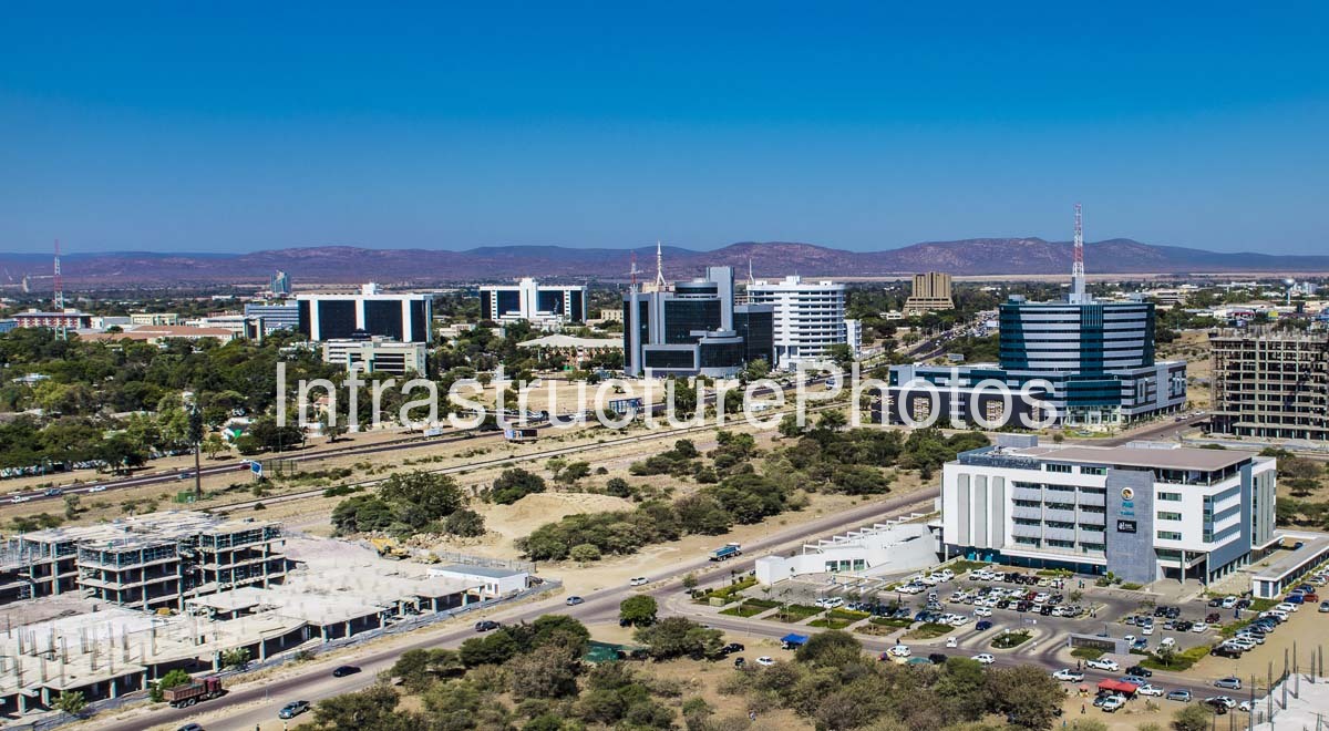
This aerial photograph presents a broad view of Gaborone, Botswana, showing the city’s evolving commercial landscape against the distinctive backdrop of the Kgale and surrounding hills. The image brings together contemporary office buildings, financial institutions, retail and commercial developments, major roads, undeveloped land and established residential areas, illustrating the rapid transformation of Gaborone into a modern regional business centre.
A prominent feature in the foreground is a First National Bank Botswana (FNB) building, identifiable by the FNB branding on its façade. FNB Botswana’s head office, known as First Place, is located in Gaborone’s Central Business District at Plot 54362. The building accommodates a range of FNB’s corporate and financial operations.
Behind the FNB building is a cluster of contemporary commercial developments that form part of Gaborone’s expanding business environment. The combination of glass façades, horizontal bands, large floor plates and modern office layouts reflects the architectural language increasingly associated with Botswana’s newer commercial buildings.
The image also captures the contrast between established development and areas still undergoing construction. At the right of the photograph, a substantial multi-storey building is under construction, with its reinforced-concrete structural frame clearly visible. This provides a useful record of Gaborone’s continued urban expansion and the development pressure experienced by the city’s commercial districts.
One of the most important areas represented in the photograph is Fairgrounds, which has developed into one of Gaborone’s principal office and commercial locations. Fairgrounds contains numerous office developments and business parks, including Fairgrounds Office Park and the Fairscape Precinct. Fairgrounds Office Park comprises the Tholo, Tsuma and Mpingo buildings, while Fairscape was developed as a major mixed-use commercial project.
The Fairscape Precinct is particularly significant within Gaborone’s contemporary architectural landscape. The development includes a 15-storey tower containing offices and residential penthouses, together with additional office and commercial buildings arranged around a central piazza. It was conceived as a mixed-use development incorporating work, retail and leisure uses.
Gaborone’s commercial architecture is characterised by a relatively low-rise urban form, making individual office buildings and newer developments particularly visible across the city. This is evident in the photograph, where modern buildings are separated by substantial areas of vegetation, open land and lower-density development.
The road network is another important element of the image. Several major routes can be seen passing through the commercial area, connecting business districts with residential neighbourhoods and other parts of the metropolitan area. The broad road reserves and relatively open development pattern reflect the planned nature of much of Gaborone’s urban expansion.
The photograph also demonstrates the relationship between Botswana’s commercial development and its natural environment. Unlike many densely developed African capitals, Gaborone retains significant areas of vegetation and open land within and around its built-up areas. Mature trees are interspersed between office developments, while undeveloped plots remain visible alongside major roads and construction sites.
The hills forming the background provide one of the strongest visual elements of the photograph. Their low, elongated profiles contrast with the increasingly vertical architecture of the city and provide a distinctive geographical setting for Gaborone. The combination of modern office buildings, open land, vegetation and the surrounding hills creates a characteristic Botswana cityscape.
Gaborone has experienced substantial commercial development since independence in 1966. The city’s traditional commercial centre around the Main Mall and Government Enclave has gradually been supplemented by newer business districts and developments. The expansion of the CBD and areas such as Fairgrounds has introduced a greater concentration of contemporary office, retail and mixed-use buildings. Historical development records note the emergence of projects such as the Square Centre, SADC Headquarters, Masa Centre and other major developments as part of this transformation.
The image therefore captures an important stage in the evolution of Gaborone’s built environment. Traditional low-rise development exists alongside newer commercial buildings with larger footprints, glazed façades and more sophisticated architectural treatments. The construction activity visible in the foreground further demonstrates that the city’s urban form continues to change.
From an aerial photography perspective, the image is particularly valuable because it places individual buildings within their wider urban context. The FNB building, surrounding office developments and construction sites can be understood not simply as isolated structures but as components of a larger commercial and transportation network.
The photograph also provides a useful architectural record of contemporary Botswana. The buildings visible demonstrate the increasing importance of modern commercial architecture to Gaborone’s identity, while the surrounding open landscape and hills retain a strong sense of place. Together, these elements create a cityscape that is distinctly different from the dense metropolitan environments found elsewhere in Southern Africa.
9.8 MB
Reviews
There are no reviews yet.