For almost fifty years, a curved slab of concrete has hung over Cape Town’s Foreshore and stopped in mid-air. Construction on the elevated freeway was halted in 1977. Since then it has been a traffic structure, a film set, a parking deck, a shelter and a punchline, but never a finished road.
That may finally change. On 2 October 2026, Mayor Geordin Hill-Lewis unveiled the Foreshore Precinct Project, a phased plan to resolve the unfinished freeways with a new bridge, a tunnel and a 15-hectare neighbourhood. Here is how the city got here and what the structure tells us.
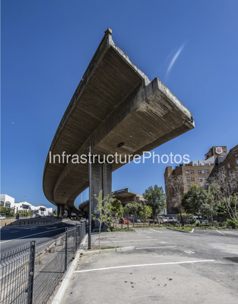
The unfinished Foreshore Freeway, Cape Town.
A freeway built on reclaimed land
The freeway’s story starts with the sea. Building the Duncan Dock in the 1930s and 1940s meant reclaiming roughly 480 acres between the old sea wall and the new quay wall. By 1947 that land was dry and ready for development, and the Cape Town Foreshore Plan set out how the city would grow onto it.
The city was under pressure. Its population had more than doubled between 1911 and 1936, from about 161,000 to 350,000, and the old street grid couldn’t take much more density. The Foreshore offered space to grow “out to sea”.
In the late 1960s, City Engineer Solomon “Solly” Morris proposed moving the Eastern and Western Boulevards and linking them with a ring highway around the city centre. The goal, in the spirit of post-war, car-first planning, was traffic “circulation with as little disturbance as possible.” The elevated spans on the Foreshore were the first pieces of that network.
Built, then abandoned: 1970s to 1977
Construction began in the early 1970s, and by 1977 several elevated sections had been built and paved. Then work stopped and never resumed.
The official explanation was simple. The budget had run out, and traffic projections no longer justified the rest of the scheme. Different sections in the eastern, western and central parts of the planned network were left disconnected from each other. The project picked up the nickname “Solly’s Folly”, after the engineer who had championed it.
What you see when you look up
The best way to understand the structure is to stand underneath it. From street level, the curved underside of the deck sweeps across the sky. It is a heavy reinforced-concrete slab that ends in a blunt, squared-off edge.
A few details reward a closer look:
- Board-marked concrete. The grain of the timber formwork is still printed across the soffit, a record of how it was cast in the 1970s.
- Single-column support. Massive single piers carry the curved deck, which leaves the ground below open for roads and parking.
- The abrupt end. The deck stops where the next span was meant to join it. The joint was never needed, so it was never built.
- Weathering. Staining, efflorescence and streaks along the edges show five decades of Cape winters on exposed concrete.
To an engineer, it is a cutaway lesson in how elevated roads are built. To everyone else, it is a strangely beautiful piece of brutalist sculpture.
Myths and legends
A half-built bridge invites stories, and Cape Town tells two favourites.
- The calculation error. Engineers supposedly got the sums wrong, so the two halves would never have met in the middle.
- The stubborn shopkeeper. A local business owner supposedly refused to sell the property the flyover needed.
Neither holds up. The record points to a more ordinary cause: the money ran out, and the traffic numbers no longer made the case for finishing. The myths survive because they are better stories than a budget shortfall.
A second life
Unable to carry traffic, the bridges found other jobs. They became a tourist landmark and one of Cape Town’s most-used film and fashion locations, appearing in productions such as Black Mirror and Fear Factor.
Finishing the job: from 2017 to the 2026 plan
Finishing the job: from 2017 to the 2026 plan
The most serious earlier attempt came in 2017. The City and Transport for Cape Town invited proposals to complete the freeways and develop the land around them, including affordable housing. Mayor Patricia de Lille said at the time that “the need for social housing in the inner city remains our core priority.” A winning bid was selected in early 2018, but by July 2018 the process had collapsed amid contracting concerns, an unclear brief and community objections.
In July 2026, Mayor Geordin Hill-Lewis announced a formal decision to complete the link. On 2 October 2026 he presented the Foreshore Precinct Project, calling it “a historic day for Cape Town” and the start of “finishing some 50-year-old unfinished business.”
The plan has three parts:
- Phase 1. A new link bridge will run from the inbound freeway to Helen Suzman Boulevard, bypassing Buitengracht, and the inbound lanes will be widened. The City will fund this phase, with construction in the next council term.
- Phase 2. An outbound tunnel will run alongside Duncan Road, and the elevated outbound freeway will be demolished. This phase runs to about 2040, with funding expected from Transnet and national government.
- The neighbourhood. About 15 hectares of CBD land will open up for mixed-use development, affordable housing, parks and a harbour-edge promenade towards Sea Point, built out over two to three decades.
No total cost has been published. Critics, including Brett Herron, have asked what it will cost to tunnel through the reclaimed Foreshore, which is made of dredged material and fill, and who carries the risk if it overruns. He pointed to Boston’s “Big Dig” as a warning. Public consultation opens now, followed by detailed design and procurement.
What a finished Foreshore could look like
Over five decades, three ideas for finishing the freeway have been put forward. To show what each could mean on the ground, we drew all three over the same aerial panorama of the city centre, looking towards Table Mountain and Lion’s Head. These are our own concept illustrations, not City designs. Building positions and bridge routes are indicative only.
Option 1: finish the 1970s freeway. The missing span is built and the stranded decks finally join the live freeway. The land underneath stays road reserve, with no housing or public space added.

Option 2: the 2017–18 deal. Developers complete the bridges in return for the right to build on the freeway reserve, including some affordable housing. This was the approach behind the cancelled 2017–18 proposal call.
Option 3: the 2026 Foreshore Precinct Project. A new bridge over Buitengracht carries inbound traffic to Helen Suzman Boulevard. The elevated outbound freeway gives way to a tunnel, and the land it frees becomes homes, parks and a tree-lined promenade towards Sea Point.
Concept illustrations by InfrastructurePhotos based on City of Cape Town announcements. Not to scale.